- On September 27, 2025
- In AREAS Neighbourhoods
London Map: Free Tourist Maps of London Transport & Attractions
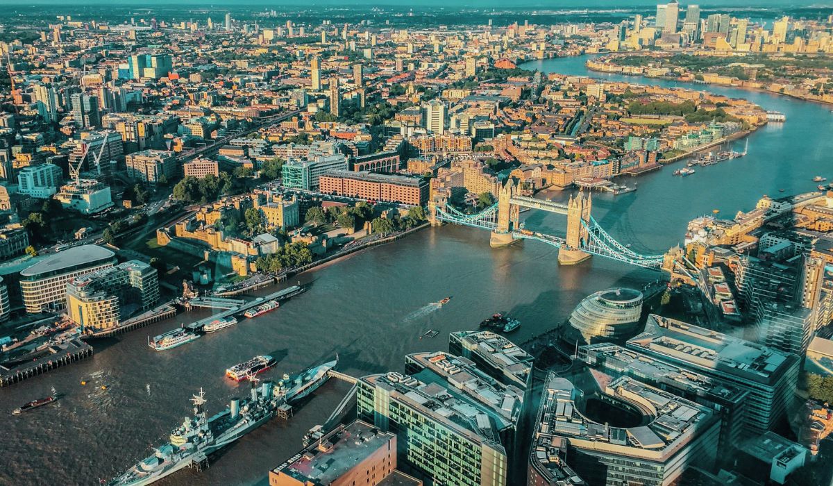
Getting ready for a trip to London? One thing’s for sure: having a good map of London at hand will save you time and headaches. The city is packed with world-famous sights, from Big Ben and Tower Bridge to the British Museum and the lively streets of Camden, but figuring out how to get from one to the other can be tricky if you don’t know your way around.
The good news? London’s transport system is one of the best in the world. You’ve got the Underground (the Tube), iconic red double-decker buses, overground trains, and even river boats gliding along the Thames. With a detailed London map, tube map, bus map, or tourist sightseeing map, exploring the city becomes effortless.
In this guide, I’ll share the most useful and free maps of London, from detailed neighborhood maps to transport and attractions maps. Whether you’re here for a weekend getaway or a full week of sightseeing, you’ll have everything you need to plan your itinerary, get around with ease, and soak up the unique vibe of the UK’s capital.
Contents
- 1 Maps of London
- 2 London Tip: How to Book Your London Eye Ticket (and Multi-Attraction Pass) 👇
- 3 London Transport
- 3.1 London Tube Map
- 3.2 Tube Stations in London for Visiting the Top Attractions
- 3.3 London Airports Map: How to Reach the City Center
- 3.4 London Heathrow Airport Map: How to Get into the City
- 3.5 London Map and Public Transport Network
- 3.6 Walking and Cycling Maps of London
- 3.7 London Hop-on Hop-Off Maps
- 4 London Hotels Map: Where to Stay in the City
- 5 Final Word : A London Map, Your Best Tool for Exploring the Capital
Maps of London
Where is London on the UK Map
Let’s start with the basics: here’s where London sits on the map of England. Seeing its location in relation to the rest of the UK helps put the capital into context, especially if you’re planning a longer trip that includes other cities.
Detailed Map of London
For a closer look, nothing beats a satellite map of London. Zoom in and you can explore the city from above, spotting landmarks and getting a feel for the neighborhoods before you even set foot there. This Google map of London is a great way to do a “virtual pre-visit” and plan which areas you’d like to discover first.
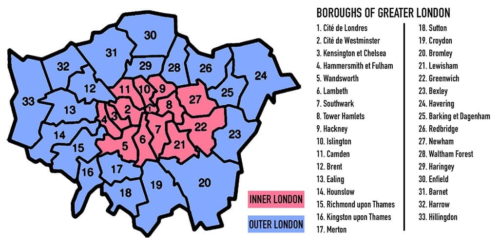
London Map: Greater London and Its Neighborhoods
When people talk about London, they’re not just referring to the historic city center.
The UK capital actually covers a much larger area known as Greater London, made up of 32 boroughs plus the City of London itself. On a map of London boroughs, you can clearly see how the city is divided into neighborhoods.
London is often described in two main parts: Inner London, which covers the historic center of the city, and Outer London, which represents the wider metropolitan area.
At the heart of the capital lies the City of London, the financial district and one of the oldest parts of the city. Right next to it is the City of Westminster, home to many of London’s most iconic landmarks, including Big Ben, the Houses of Parliament, and Westminster Abbey.
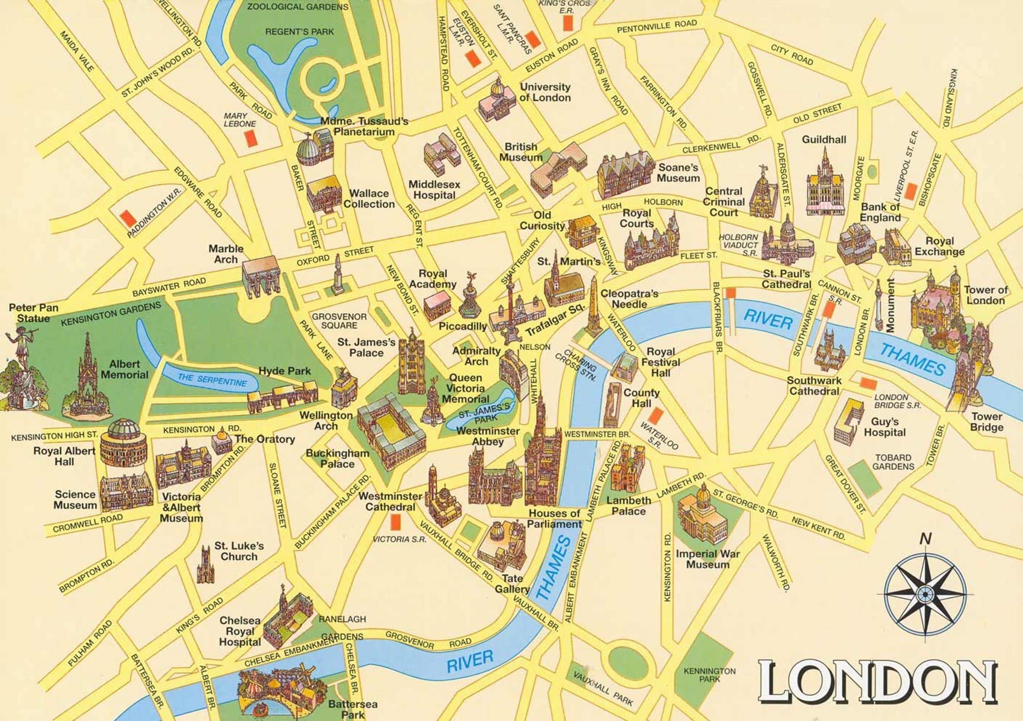
London Map: The Historic Center and Its Landmarks
The illustrated map of central London below highlights the city’s main landmarks, especially around the City of London and Westminster.
This is where you’ll find many of the capital’s most famous sights, including Buckingham Palace, the official residence of the British monarch.
This type of tourist map of London is perfect for getting an overview of the must-see attractions in the historic center.
![]() Tip – And if you’re planning to visit several of these monuments, I highly recommend looking into the London Pass. Depending on your itinerary, it can save you both time and money.
Tip – And if you’re planning to visit several of these monuments, I highly recommend looking into the London Pass. Depending on your itinerary, it can save you both time and money.
London Tip: How to Book Your London Eye Ticket (and Multi-Attraction Pass) 👇
Want to ride the London Eye, the city’s famous observation wheel, during your trip? Great idea!
The London Eye is operated by Merlin Entertainments, the same company behind popular attractions like Madame Tussauds, SEA LIFE Aquarium, and the London Dungeon.
Here’s the smart tip: Merlin offers money-saving combo tickets that let you bundle several attractions together. You can even add extras like a Thames River Cruise or a Big Bus hop-on hop-off tour and save a lot compared to buying tickets separately.

To grab this London deal, head straight to the official London Eye website and check the offers on this page >>.
![]() Pro Tip : Keep the page in English. Some of the best special deals don’t appear if you switch to another language : I explain everything in detail in my Merlin Magical Pass review article.
Pro Tip : Keep the page in English. Some of the best special deals don’t appear if you switch to another language : I explain everything in detail in my Merlin Magical Pass review article.
Printable London Map with Tourist Attractions
Here’s a simple printable map of London (click here to print) that shows the main landmarks and points of interest across the city. It’s free and super handy whether you’re planning your sightseeing list in advance or just want something practical to carry around for a bit of spontaneity once you’re there.
London Sightseeing Map and Itinerary: The Must-Sees in One Route
And now, here’s a suggested London sightseeing route that covers the city’s unmissable highlights.
This itinerary is tried and tested, and you’ll find the full details in my article: My 3 Days in London Itinerary.
There, you’ll get more information on each stop along the way, plus a few insider tips to make your trip even smoother.
London Transport
London Tube Map
Let’s start with the London Underground, the world’s very first urban subway system, opened back in 1863. Locals simply call it “the Tube”, and it’s still the easiest way to get around the city today.
The network now has 11 lines, covering 9 travel zones, and trains run from about 5:00 am until midnight. It’s operated by Transport for London (TfL), where you’ll also find key information such as:
Below, you’ll find the main London public transport map, which shows how the Tube connects with buses, trains, and other services across the city.
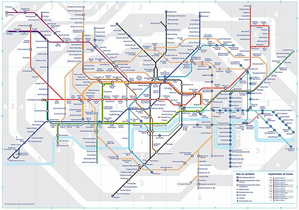
Tube Stations in London for Visiting the Top Attractions
Here’s a quick guide to the nearest Underground stations for some of London’s most famous tourist sites. With a map of London Tube in hand, it’s easy to connect the dots and plan your sightseeing:
- London Eye
- Waterloo Underground Station – Bakerloo, Northern, Jubilee, Waterloo & City lines
- Sky Garden
- Monument Station – Circle and District lines
- Tower of London
- Tower Hill Station – Circle and District lines
- Buckingham Palace
- St. James’s Park Station – Circle and District lines
- Victoria Station – Circle, District and Victoria lines
- Hyde Park Corner Station – Piccadilly line
- Westminster Abbey
- St. James’s Park Station – Circle and District lines
- Westminster Station – Circle, District and Jubilee lines
- The Shard
- London Bridge Station – Jubilee and Northern lines
- Tower Bridge
- Tower Hill Station – Circle and District lines
- London Bridge Station – Jubilee and Northern lines
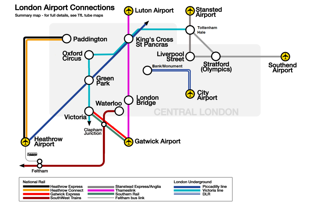
London Airports Map: How to Reach the City Center
Did you know London has six airports? That’s a lot for one city!
Each airport has its own transport options to get you into central London : from trains and Underground links to buses, shuttles, and private transfers.
Covering them all here would take too long, so I’ve put together a dedicated guide: How to Get from London Airports to the City Center. It details the best routes for six of London’s main airports, so you’ll know exactly what to expect when you land.
In the meantime, here’s a handy map of London airports to help you see where they are located around the city.
London Heathrow Airport Map: How to Get into the City
Heathrow is London’s busiest airport and one of the largest in the world. If you’re flying into the UK capital, chances are you’ll land here.
A London Heathrow airport map is the best way to understand the layout of its five terminals, as well as the transport options that connect Heathrow airport to central London. From the terminals, you can easily access:
- The Heathrow Express (fastest train to Paddington Station)
- The London Underground Piccadilly Line (direct Tube service into the city)
- Coaches and buses for budget-friendly connections
- Taxis and private transfers for door-to-door convenience
![]() Tip – You can find the official Heathrow map PDF on the airport’s website, showing terminals, facilities, and transport links. It’s worth saving it on your phone before you arrive to make your journey smoother.
Tip – You can find the official Heathrow map PDF on the airport’s website, showing terminals, facilities, and transport links. It’s worth saving it on your phone before you arrive to make your journey smoother.
London Map and Public Transport Network
For even more details, you can check all the official London maps and timetables directly on the Transport for London (TfL) website.
Here are the most useful maps for getting around:
These resources are updated regularly and give you the full picture of how the city’s transport system connects together.
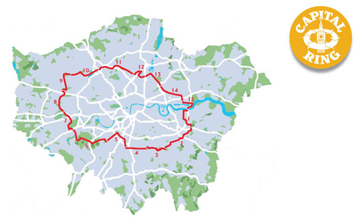
Walking and Cycling Maps of London
London is one of those cities where you can easily spend hours just exploring on foot. A London walking map is the perfect way to plan a self-guided stroll through the city’s historic streets and iconic neighborhoods. From Westminster to Covent Garden, Soho to Southbank, walking is often the best way to soak up the atmosphere and discover hidden gems along the way.
For cyclists, the capital is also becoming more and more bike-friendly. A London cycling map will show you the network of cycle lanes, quiet routes, and docking stations for the popular Santander Cycles (London’s bike-share scheme). It’s an affordable and eco-friendly way to get around, especially for shorter journeys.
You can download official walking maps and cycle maps of London from the Transport for London (TfL) website (on this page and also on this page). They’re a great resource if you want to mix sightseeing with a bit of fresh air and exercise.
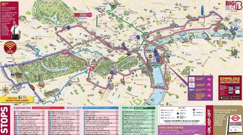
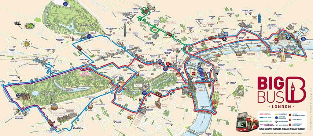
London Hop-on Hop-Off Maps
This time, let’s not start with the buses, but with cruises and guided tours on the Thames.
The river offers a completely different perspective on the city, with unique views of some of London’s most famous landmarks. It’s a peaceful and original way to explore the capital. For more details, check out my guide: Hop on Hop Off London boat tours.
If you’d prefer a guided tour, no problem. In my article The Best Guided Tours of London, you’ll find great options with knowledgeable local guides.
And of course, there are the classic London hop-on hop-off bus tours. Companies like City Sightseeing (last price here), Big Bus (see here), and Golden Tours (check here) all offer routes that cover London’s top attractions.
To give you an idea of what these tours look like, here’s an example from Big Bus : their London hop-on hop-off map is one of the clearest and easiest to follow.
London Hotels Map: Where to Stay in the City
Choosing the right area to stay in London can make a big difference to your trip. The London hotels map below helps you quickly compare locations and find the best accommodation close to the attractions you want to see.
![]() Tip – If it’s your first time in London, you might want to stay near the West End or Covent Garden, where you’ll be close to theatres, restaurants, and landmarks. For a more local vibe, areas like Shoreditch or Camden are full of energy and nightlife.
Tip – If it’s your first time in London, you might want to stay near the West End or Covent Garden, where you’ll be close to theatres, restaurants, and landmarks. For a more local vibe, areas like Shoreditch or Camden are full of energy and nightlife.
And if budget is your main concern, my London neighborhood hotels map will show you cheaper areas with good Tube connections.
Most booking platforms let you view hotels directly on an interactive map of London (like the one below), so you can see prices, ratings, and locations at a glance. It’s the easiest way to find the perfect spot, whether you’re looking for a luxury stay or a budget-friendly option.
Final Word : A London Map, Your Best Tool for Exploring the Capital
London is a city best explored both on foot, wandering through its lively neighborhoods, and by making the most of its world-famous public transport network. With a detailed London map, plus the essential Tube map, bus maps, and tourist sightseeing maps, you’ll be able to plan your trip with ease and move effortlessly between must-see attractions like Big Ben, the Tower of London, the British Museum, the London Eye and Camden Town.
Whether you’re here for a 3-day London itinerary or a full week, these free London maps will help you save time, cut down on transport costs, and enjoy the monuments and atmosphere of the UK capital to the fullest.
So don’t forget to download your London map PDF before you go and mark out your itinerary, exploring London has never been simpler or more enjoyable.
👉 And how about you? Have you already tried riding the Tube or hopping on a red double-decker bus to see the city? Share your tips and experiences in the comments to inspire fellow travelers!

I’m Sebastian and I love exploring and writing about London. I’ve spent lots of time wandering around the city, finding cool places and learning all the best things to do. On my blog, LondonPass.info, I talk about all the awesome spots in London, from the famous ones everyone knows to secret places that are super special.